Patterson Guard Station
Eagleville, California · USDA Forest Service
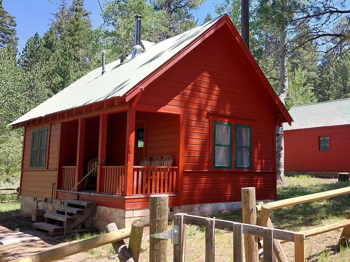
Photo: Recreation.gov
About
*Altitude is 7,080 feet above sea level* Set on the edge of a meadow surrounded by Aspen, Fir and Pine trees, Patterson Guard Station has stood since 1921. It served the Modoc National Forest as a fully staffed fire office and guard station until 1981. Just a few footsteps from the Summit Trail and one-quarter mile from the wilderness boundary, Patterson Guard Station can be your basecamp for trips into the South Warner Wilderness or the perfect place to disconnect and relax. The cabin only has one set of bunkbeds (two mattresses). There is a large turn-around parking area directly adjacent to the cabin which can accommodate camper trailers, smaller RVs and gooseneck horse trailers. No hook-ups . If your party exceeds 8 persons, the adjacent Patterson Campground offers 6 developed campsites for $15/night. Click here to view the full reservation calander and additional details not included on this page. Blue Lake, 9 miles West, offers a boat ramp and dock with a kayak launcher, fishing platform, day use area with grills and picnic tables and a developed campground with 40+ developed campsites at $15/night. Cedarville, California, is a historic western town offering restuarants, a grocery store, and shopping oppourtunities. 31 miles North along County Road 1. Hiking & Horseback Riding The nearby trails within the South Warner Wilderness offer wild landscapes and solitude for hikers and horseback riders. The Wilderness Act of 1964 prohibits the use of motorized and/or mechanized equipment within the Wilderness area (limited exceptions are provided by the Americans with Disabilities Act). South Warner WIlderness maps are advised and always available at the Modoc National Forest Supervisor's Office in Alturas, Calif. Maps may also be available at the Likely General Store in Likely, Calif. Off-Highway Vehicles Many of the roads near Patterson Guard Station, outside of the wilderness area, are open to Off-Highway Vehicles. Motor Vehicle Use Maps are available online and at the Modoc National Forest Supervisor's Office in Alturas, Calif. Boating Blue Lake, 9 miles west, features a boat ramp and dock for motorized and non-motorized watercraft. Help keep this lake clean by following the California Invasive Species Prevention Program Please respect the 10 mph speed limit on the lake. If speed-boating is your thing, consider launching your boat at West Valley Reservoir instead. This location is unstaffed. To speak with our main office for general information, please c
Directions
From Alturas, California, travel South on U.S. Highway 395 for 18 miles to the town of Likely and Turn left (East) onto County Rd 64. Continue for 9 miles toward Jess Valley and stay right at the fork toward Blue Lake (Blue Lake Road), this road is not maintained for winter travel . The pavement ends in approximately 6.5 miles, and the road becomes Forest Road 39N01 (South Warner Road). Continue 7.5 miles and turn left (North) at the sign for Patterson Campground (Forest Road 39N28), stay left to reach Patterson Guard Station.
Location
Map tiles © OpenStreetMap.
Details
- State
- California
- City / area
- Eagleville
- Agency
- USDA Forest Service
- Parent area
- Modoc National Forest
- Campsites
- 1
- Reservable
- Yes
- Typical price
- $75 / night
- Rating
- 4.25 / 5 (8 reviews on Recreation.gov)
- Equipment
- See Recreation.gov
Nearby campgrounds
- Blue Lake Campground Group Site - Modoc NF (CA) 9.8 km away
- Dodge Reservoir Campground 25.7 km away
- Divine Springs Campground 32.1 km away
- Ramhorn Springs Campground 54.6 km away
- Lassen Creek Campground 70.4 km away
- Aspen Grove Campground (CA) 86.8 km away