MEDICINE POINT LOOKOUT
Darby, Montana · USDA Forest Service
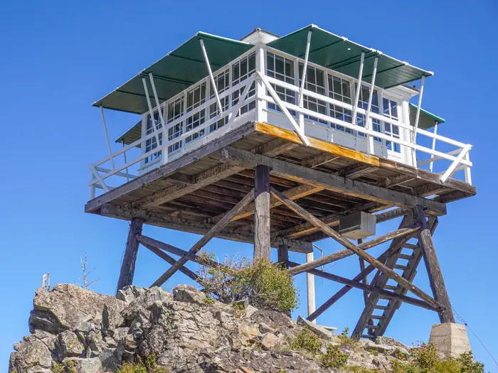
Photo: Recreation.gov
About
Medicine Point Lookout is a historic tower located on Medicine Point, west of Sula. It has been restored to reflect a lookout of the 1940s, including the stove, furniture, dishes and other small touches. It offers a unique chance for visitors to camp on a mountain peak, near the scenic Bitterroot River in a rustic, old-time setting, while having the enjoyment of recreating on public lands. The tower provides spectacular views of the surrounding western Montana wilderness. Medicine Point Lookout is a historic "L4" lookout located on Medicine Point, west of the Bitterrot Valley. The lookout is one room cabin with a bed platform suitable for two people. Bedding is not provided. The lookout can accomidate up to four people. Others are welcome to tent camp in the area. The lookout measures 14ft.X14ft. with a 30 inch catwalk around the outside. There is wood stove for heat. You may have to saw your own wood from dead and down material found nearby. A bow saw and ax are provided. A two burner propane campstove and lanterns are provided. Propane is not provided, you will need to bring your own propane canisters . Basic eating and cooking utensils are provided. There is no water available near the lookout so please bring your own water . An outdoor toilet serves the lookout. You will need to provide your own toilet paper . The lookout is built on a 10 foot tall tower, with narrow steps and catwalk. This may pose a hazard for children and pets. Guests are responsible for their own safety. Remember, guests will need to bring their own water for drinking, cooking and cleaning purposes, as well as propane fuel canisters for cooking and lighting. Guests are also responsible for their own bedding, towels, soap, toilet paper and garbage bags. The facility does not provide trash receptacles; all garbage must be carried out, and the tower must be cleaned by guests prior to leaving. Do not leave anything you bring, even if you think it will benefit other renters. The tower is accessed by a somewhat difficult 3.5-mile hike from the parking area with a 2,000 foot elevation gain. Snowmobiles and other off-road vehicles are not allowed on the trail, however, horses and other livestock are welcome. Guests are responsible for their own travel arrangements and safety, and must bring several of their own amenities. The tower is poised between the east and west forks of the Bitterroot River at an elevation of 8,409 feet. It offers beautiful views of the Bitterroot Mountains, as well
Directions
From Missoula, Montana, travel south on Highway 93 to Laird Creek Road/Forest Service Road 370, which is approximately 34 miles south of Hamilton. Turn right and continue about 4 miles to Bear Creek Saddle. At Bear Creek Saddle, turn north onto Forest Service Road 5731 and continue 2 miles to the trailhead. The trail to the tower is approximately 3.5 miles and is quite steep along some portions, gaining 2,000 feet of elevation.
Location
Map tiles © OpenStreetMap.
Details
- State
- Montana
- City / area
- Darby
- Agency
- USDA Forest Service
- Parent area
- Bitterroot National Forest
- Campsites
- 1
- Reservable
- Yes
- Typical price
- $30 / night
- Rating
- 4.90 / 5 (10 reviews on Recreation.gov)
- Equipment
- See Recreation.gov
Nearby campgrounds
- Crazy Creek Campground 3.3 km away
- Warm Springs Campground 6.7 km away
- TWOGOOD CABIN 7.5 km away
- SPRING GULCH 8.8 km away
- INDIAN TREES CAMPGROUND 13.4 km away
- ROMBO 14.0 km away